Why a River Bend Moves Across a Floodplain
Why a river bend moves across a floodplain becomes clearer when you read cut banks, sand deposits, and abandoned channels as connected clues.
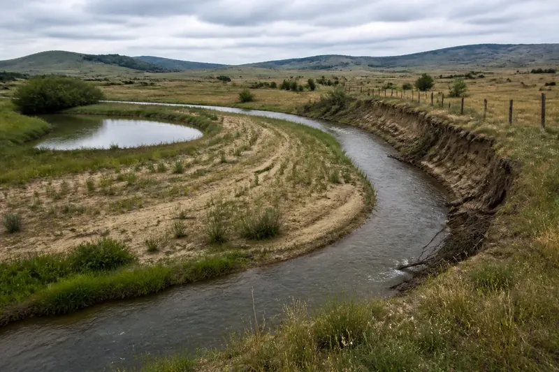
At the edge of a western pasture, a creek may run beside a fence that once stood well back from the water. Across the meadow, a crescent-shaped pond marks an older route. To understand why a river bend moves across a floodplain, look for the small clues left by erosion and deposited sediment, not just the channel visible today.
A meandering river shifts as current wears away one bank and lays sediment along another. Floods can speed that process or open a new route, while abandoned bends remain as marks in the ground. Read the channel, its banks, and nearby landforms together, and consider what high water may have changed.
Read the channel
Before deciding which way a bend is moving, make sure you are looking at an active channel. A dark line on an aerial image could be a flowing creek, a wet swale, a drainage ditch, or a former channel that fills only during high water. From a safe viewpoint, look for moving water, fresh sediment, damp banks, and a connected path upstream and downstream.
Trace the channel’s shape rather than judging one curve on its own. A bend usually belongs to a sequence: water swings one way, turns back, and continues across the floodplain. That sequence can reveal the river’s broad pattern even where grasses hide the water’s edge.
Compare a recent aerial view with a topographic map, then look from a safe public viewpoint. Maps can help distinguish a looping channel from a straight artificial ditch, but the land itself may show details that a map smooths over.
Spot the cut bank
The outside edge of a bend often has a steep bank, exposed roots, or a raw face of soil. This is the cut bank, where faster current presses against the curve and removes material. Leaning trees or undercut turf may suggest ongoing erosion, though one isolated slump can have another cause.
Look for several clues along the same outer curve. A fresh scar beside older, grassed-over erosion can suggest that the river has trimmed the bank in stages. If the water touches a steep bank on one side and a shallow shelf lies opposite, the contrast fits the usual pattern of outer-bank erosion and inner-bank deposition.
Follow the outer edge from a distance and note whether bare soil, exposed roots, or fallen branches recur along the curve. Stay off undercut banks; the surface can look solid while water has removed soil below.
A fallen tree alone does not prove that the whole bend is migrating. Wind, saturated soil, or a local bank failure may explain it. A repeated pattern of erosion along a curved reach, paired with signs of sediment settling across from it, offers a more coherent reading.
Find the point bar
On the inside of a bend, the current slows and drops sand, silt, and gravel. This deposit is called a point bar. It may appear as a gently sloping shelf, a sandy patch at low water, or a curved ridge beneath grass and shrubs.
Point bars can build outward in thin, curved layers. Look for arcs that echo the present bend, changes in vegetation, or a shallow margin where fine sediment has settled. Plants or high water may hide a bar, so its absence from view does not mean deposition is absent.
Compare both sides of the same bend. If the inside is broad and gently sloped while the opposite bank is steep or freshly cut, the contrast helps explain how a river can shift sideways without moving its entire course at once.
Not every sandy patch is a point bar. A tributary, road crossing, or built structure may alter local flow and leave its own deposit. Check whether the patch follows the bend and whether similar deposits appear nearby.
Trace old channels
Floodplains keep partial records of routes the river no longer follows. An abandoned bend may survive as an oxbow pond, a damp crescent, a shallow trough, or a curved band of different vegetation. These features can be subtle when sediment fills the old channel or fields have been leveled.
Look for a crescent that parallels the present river, with ends that once connected to the main channel. A broad loop that has been cut off may hold standing water in one part and dry ground in another. In a dry landscape, a former channel may show most clearly as darker soil or denser plants after rain.
Follow the suspected curve beyond its wettest patch. A single pond may be unrelated, but a continuous crescent-shaped depression aligned with the river is a stronger sign of an old bend. Compare it with the surrounding floodplain rather than relying on color alone.
Say you are looking at an invented pasture where a creek now runs along the east side of a broad loop. A crescent pond lies west of the current channel, a low sand ridge curves along the loop’s inner edge, and the east bank shows exposed soil. Read together, these clues suggest that the creek has been cutting the outer bank and building sediment on the inner one before abandoning part of the loop. The pond, ridge, and bank make more sense as related marks than as unrelated features.
What happens during floods?
Why can high water change a bend?
High water spreads across more of the floodplain and can carry sediment and debris beyond the usual channel. Strong flow may erode a weak bank, cut across a narrow neck between bends, or deposit fresh material where water slows. The visible result may be a changed shoreline, a new shallow channel, or a fresh layer of silt.
Can a river cut through a bend?
Yes. If floodwater crosses the narrow strip of land between two parts of a loop, it may establish a shorter route and leave the old bend partly or fully disconnected. The former channel can persist as a pond, wet hollow, or dry crescent, depending on water supply and sediment.
How can I tell a natural channel from a ditch?
A natural channel often curves irregularly and connects with other floodplain features, while a constructed ditch may be unusually straight or follow a property, road, or drainage line. Neither clue settles the question alone; local land records and site evidence can clarify what shaped a particular feature.
Why is an old channel still wet?
An abandoned channel may collect rain, receive groundwater, or remain connected to the river during high water. Its water level can change with season and weather, and some old channels dry out while retaining a damp, low-lying shape.
Read floodplain patterns
A river’s shifting bends leave more than isolated banks and ponds. Across the floodplain, look for ridges, swales, wet hollows, and bands of different soil. Point bars may form slightly higher ground; abandoned channels can remain lower and wetter. Together, these features record where water moved and where it dropped sediment.
Vegetation can help you read that record. Willows or other moisture-loving plants may follow a channel that is no longer obvious, while a drier ridge may support different grasses. Treat plant patterns as clues, not proof: grazing, irrigation, soil type, and land management also shape what grows.
Compare several bends rather than drawing a conclusion from one. Repeated outer-bank scars and inner-bank deposits suggest a consistent process. If the pattern changes near a bridge, diversion, levee, or field drain, a human alteration may be influencing the river locally.
Weigh conflicting clues
Floodplain evidence is often incomplete. Vegetation can hide a bend, sediment can fill an old channel, and a recent flood can erase earlier marks. Seasonal water, livestock trails, and cultivation may also make natural features harder to distinguish.
When clues disagree, give more weight to features that align: a curved trough, a matching ridge, and an erosion scar along the present bend make a more coherent reading than any one feature alone. If the land has been heavily altered, compare current views with older maps or aerial photographs where available, and keep the interpretation tentative.
For a property boundary, drainage dispute, or decision about building near a river, a visual reading is not enough; consult an appropriate local professional or agency. Floodplain rules and river conditions vary by place, and a map’s apparent dry ground does not establish that a site is safe from flooding.
Skip false precision
You do not need to estimate how quickly a bend moves or assign an age to every crescent. Such guesses can sound exact while resting on clues with several possible explanations. It is not worth the effort to infer a river’s full history from one aerial image or one brief visit.
Instead, describe what you can see: a steep outer bank, a shallow inner bar, a curved depression, or a wet strip of vegetation. Then ask how those features fit together. That careful reading explains why a river bend moves across a floodplain: the channel shifts, sediment settles, and the land preserves fragments of routes water has left behind.